
As if the extreme heat across the country this week hasn’t been bad enough, now there are major thunderstorms on the horizon.
The Met Office has issued three thunderstorm warnings covering 112 areas across the UK, with heavy rain, lightning, hail, and strong winds expected to bring disruption as the recent heatwave comes to an end. The warnings cover parts of Scotland, Northern Ireland, England and Wales, with forecasters warning that conditions could change quickly throughout Friday.
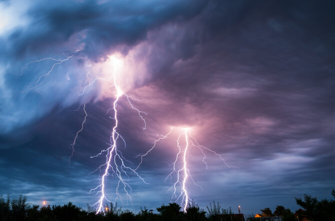
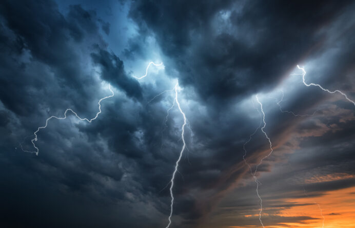
Three thunderstorm warnings have been issued across the UK.
The yellow weather warnings all come into force from midnight and cover large parts of Britain. While not every location inside the warning areas will experience severe weather, the Met Office says those that do could see torrential downpours, frequent lightning, large hail and strong wind gusts.
Forecasters say thunderstorms are expected to develop first across northwest Scotland before spreading more widely during Friday morning. Further outbreaks of heavy rain and thunderstorms are then expected to develop across other parts of the UK during the day, before gradually clearing from southern areas and becoming confined to northern Scotland later in the afternoon and evening.
Flooding and travel disruption are possible (and even likely).
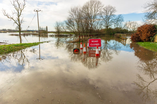
The Met Office says heavy downpours could cause spray and sudden flooding on roads, making driving conditions difficult in some areas. There’s also a risk of temporary road closures where flooding develops quickly.
Train and bus services could also face delays or cancellations, while lightning strikes, strong winds and hail may create further disruption. Rainfall totals will vary considerably, but some places could see between 20 mm and 30 mm of rain in just one hour, with isolated areas receiving up to 50 mm within three hours.
Strong winds, lightning, and hail are also expected.

As well as heavy rain, some thunderstorms could produce frequent lightning, hailstones measuring between 2 cm and 4 cm across and wind gusts reaching between 50mph and 60mph, particularly across parts of England and Wales.
The Met Office says not every area inside the warning zones will experience thunderstorms. However, where storms do develop they could become intense in a short space of time, meaning local conditions may deteriorate quickly even if neighbouring areas remain dry.
Scottish roads are being treated as temperatures soar.

While many parts of the UK prepare for thunderstorms, some areas of Scotland are still expected to experience exceptionally high temperatures. The Scottish Borders could see temperatures reaching around 31C, with road surface temperatures climbing well above that.
To prevent roads from becoming damaged, Scottish Borders Council has been sending gritters onto the roads. Instead of spreading salt, the vehicles are applying a fine layer of sand to stop hot road surfaces becoming soft and the tar beginning to melt during the hottest part of the day.
Areas affected in Scotland

The Scottish warning covers a large part of the country, including the Highlands, central Scotland and much of the east and west. The affected areas are:
Angus
Clackmannanshire
Dundee
Falkirk
Fife
Perth and Kinross
Stirling
Aberdeen
Aberdeenshire
Moray
Na h-Eileanan Siar
Highland
Orkney Islands
Dumfries and Galloway
East Lothian
Edinburgh
Midlothian
Scottish Borders
West Lothian
Argyll and Bute
East Ayrshire
East Dunbartonshire
East Renfrewshire
Glasgow
Inverclyde
North Ayrshire
North Lanarkshire
Renfrewshire
South Ayrshire
South Lanarkshire
West Dunbartonshire
Areas affected in Northern Ireland

The warning in Northern Ireland covers all six counties, where heavy showers and thunderstorms are expected to move north during Friday morning. The affected areas are:
County Antrim
County Armagh
County Down
County Fermanagh
County Londonderry
County Tyrone
Areas affected in England
The warning for England covers a wide area stretching from the North East and Yorkshire to the Midlands, North West, South West and parts of southern England. Thunderstorms are expected to move north-eastwards during the early hours before gradually clearing later in the morning. The affected areas are:
Bath and North East Somerset
Blackburn with Darwen
Blackpool
Bournemouth, Christchurch, and Poole
Bristol
Cheshire East
Cheshire West and Chester
Cumbria
Darlington
Derby
Derbyshire
Devon
Dorset
Durham
East Riding of Yorkshire
Gateshead
Gloucestershire
Greater Manchester
Halton
Hampshire
Hartlepool
Herefordshire
Lancashire
Leicestershire
Merseyside
Middlesbrough
Newcastle upon Tyne
North Lincolnshire
North Somerset
North Tyneside
North Yorkshire
Northumberland
Affected areas in England continued…

Nottingham
Nottinghamshire
Oxfordshire
Redcar and Cleveland
Shropshire
Somerset
South Gloucestershire
South Tyneside
South Yorkshire
Staffordshire
Stockton-on-Tees
Stoke-on-Trent
Sunderland
Swindon
Telford and Wrekin
Torbay
Warwickshire
Warrington
West Midlands
West Yorkshire
Wiltshire
Worcestershire
York
Areas affected in Wales
Much of Wales is also included in the warning area, with heavy rain, thunderstorms, lightning and hail all possible during Friday.
The affected areas are:
Blaenau Gwent
Bridgend
Caerphilly
Cardiff
Carmarthenshire
Ceredigion
Conwy
Denbighshire
Flintshire
Gwynedd
Merthyr Tydfil
Monmouthshire
Neath Port Talbot
Newport
Powys
Rhondda Cynon Taf
Swansea
Torfaen
Vale of Glamorgan
Wrexham
How to stay safe during the warnings

The Met Office advises people to keep up to date with the latest forecasts as thunderstorm warnings can change quickly. Conditions may vary significantly over short distances, meaning one town could experience torrential rain while another nearby stays dry.
If you’re travelling, it’s worth allowing extra time for your journey and checking for any disruption before setting off. Drivers should take extra care on flooded roads, while anyone outdoors should move inside if thunderstorms develop. Keeping an eye on local weather updates throughout the day will help you stay prepared as the warnings move across the UK.